|
Guatemala is known as Land of the Eternal Spring; a well deserved name that is evocative of the country's lush tropical setting, flowing rivers, and a year round climate that is as close to perfect as anywhere on earth. Guatemala is the northern most country in Central America located at the end of the Central American isthmus and is bordered by Mexico to the north, the Pacific Ocean to the west, the Caribbean Sea and Belize the east, and El Salvador and Honduras to the southeast.
Guatemala's population,
the highest of any Central American country, is roughly
13 million (July 2001 estimate). The country is also host
to the largest indigenous population in all of Latin America
today. The great majority of the indigenous population
are the Maya. Most Guatemalan citizens live in or around
Guatemala City and the western highlands. The population
is nearly evenly divided between native Americans and
Mestizos (known also as Ladinos), a
people of mixed European and indigenous Maya ancestry.
 There are two seasons in Guatemala: the rainy season and the dry season. The rainy months run from May to October, the dry from November to April. The average year round temperature is 75 degrees. There are two seasons in Guatemala: the rainy season and the dry season. The rainy months run from May to October, the dry from November to April. The average year round temperature is 75 degrees.
Nearly two-thirds of the country
is comprised of towering mountain ranges, with peaks in the Sierra
de las Minas range that rise to an elevation of up to 12,000 feet.
Dominating the Guatemalan landscape are thirty three volcanoes,
several of which are still active. In addition to its striking geologic
setting, the land is host to many more geographical contrasts. From
the lush tropical rain forests to the north, the fertile plains
and temperate plateaus of the south and east, the beautiful highland
lakes, the wonderful rivers, and pristine coastlines of the Pacific
Ocean and Caribbean Sea, Guatemala is a destination not to be missed.
Most plants typical of tropical areas are
found in the Guatemalan lowlands to the north. In the mountain regions, oak trees
predominate on lower slopes, giving way to pine forests above 2100 m (7000 ft).
Deer, monkeys, tepescuintle (a type of giant guinea pig), and wild pigs, known
as peccaries, are common in the sparsely populated lowlands. Other wild animals—including
jaguar, tapir, and puma—are found in smaller numbers, and crocodiles inhabit
some rivers. Bird life is extremely rich, and the rare and endangered Quetzal
serves as a symbol of the country. Its bright emerald green feathers, the color
of the most precious jade, was the most esteemed material in all of ancient Mesoamerica.
Guatemala's primary natural resource is the rich soil of its highland valleys
and coastal plains, but it also has some petroleum, as well as nickel, lead,
zinc, iron, and small quantities of gold, silver, and jade.
Guatemala is also host to the largest and most important collection of Maya ruins in Central America, as well as vast treasures of Pre-Columbian artifacts housed in it's 15 major museums. Almost two thousand years before Columbus landed on the shores of Central America, the Maya had developed the four main compass points used in marine navigation. They developed a complex and extremely accurate calendar which is still used today for planning crops and fishing. Evidence of this ancient history is apparent wherever you go.
 Return to top Return to top
Guatemala City is a fast growing cosmopolitan city that
blends the charms of an eighteenth century city with the dynamic vitality of
a modern day metropolis. With important museums, churches of all denominations,
theaters, markets, shopping malls and both public institutions and private corporations,
the city is the hub and nerve center of Guatemala. Surrounded by mountains and
volcanoes, Guatemala's capital city enjoys year-round springtime weather and
a climate that is the envy of visitors. Guatemala City has experienced a great
deal of growth over the last three decades and now is home to over two million
inhabitants. Principle agricultural products include coffee, corn, carrots and
apples. Principle industries include light manufacturing, food processing, beverage
bottling plants, retail, and textiles.
Guatemala's political and economic climate is also extremely tourist friendly. Foreigners are welcomed as a vital segment of the national financial lifeblood. The value of its currency, the Quetzal, when compared to other currencies makes Guatemala a very affordable destination. A center of social life in Guatemala are the Markets, there you will find great bargains on exquisite fabrics and textiles, art, handcrafts and delicious food.
Guatemala is a surprisingly modern country, with up-to-date communications, internet service, shopping malls, health care, and public transportation. Whether its the nonstop hustle and bustle of Guatemala City, the pristine colonial splendor of Antigua, the bohemian feel of Panajachel, the awe inspiring ruins of Tikal, or steamy tropical nights on the Rio Dulce, Guatemala has what you are looking for.
Return to top
The Western Highlands is the most mountainous part of the country. The departments of Quetzaltenango, San Marcos, Totonicapan and Huehuetenango are located here as well as the countries second largest city, Quetzalteneango also known as "Xela" or "Xelaju". The principle industries of this region are hand-woven and manufactured textiles, regional handicrafts for export, furniture, ceramics and blown glass. Principle agricultural products are corn, wheat, coffee, fruits and wool. The western highlands can be accessed by the Inter-American highway which runs through most of the region and can also be accessed by the Pacific Coastal Highway.
 The Central
Highlands are made up of the departments of Chimaltenango,
Sacatepequez (Antigua) and Sololá (Lake Atitlan, Panajachel). The colonial
town of Antigua located just 20 minutes from Guatemala City is the main tourist
destination in Guatemala, known for it's rich colonial heritage, scenic yet imposing
volcanoes, and it's world renown Spanish language schools as well as it's Easter
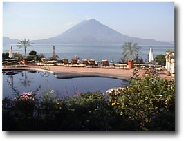
processions (Semana Santa). In the department of Sololá the traveler finds
another gem in the form of Lake Atitlan (pictured at right), considered by many
to be the most beautiful lake in the world, its actually a caldera formed by
volcanic activity. The lake, based at 5100 feet is more than one thousand feet
deep and is roughly 7 miles across by 11 miles wide and on its southern side
adorned by three prominent volcanoes (San Pedro, Atitlan and Toliman), none
of which are active. Panajachel is the main tourist center on the lake full of
international restaurants and hotels as well as colorful textiles and crafts,
from here you can explore by either boat, car, bicycle, motorcycle, horseback
or just hiking the many indigenous villages all with a distinct language and
traditional dress. Some of the principle agricultural products include coffee,
corn, wheat, baby vegetables, cut flowers and fruits. Industries include drawback
textile operations, hand woven textiles, vegetable packing and regional handicrafts
for export. Antimony, iron, titanium and copper can be found in this region.
The Inter-American highway is the primary access to the region. The Central
Highlands are made up of the departments of Chimaltenango,
Sacatepequez (Antigua) and Sololá (Lake Atitlan, Panajachel). The colonial
town of Antigua located just 20 minutes from Guatemala City is the main tourist
destination in Guatemala, known for it's rich colonial heritage, scenic yet imposing
volcanoes, and it's world renown Spanish language schools as well as it's Easter
processions (Semana Santa). In the department of Sololá the traveler finds
another gem in the form of Lake Atitlan (pictured at right), considered by many
to be the most beautiful lake in the world, its actually a caldera formed by
volcanic activity. The lake, based at 5100 feet is more than one thousand feet
deep and is roughly 7 miles across by 11 miles wide and on its southern side
adorned by three prominent volcanoes (San Pedro, Atitlan and Toliman), none
of which are active. Panajachel is the main tourist center on the lake full of
international restaurants and hotels as well as colorful textiles and crafts,
from here you can explore by either boat, car, bicycle, motorcycle, horseback
or just hiking the many indigenous villages all with a distinct language and
traditional dress. Some of the principle agricultural products include coffee,
corn, wheat, baby vegetables, cut flowers and fruits. Industries include drawback
textile operations, hand woven textiles, vegetable packing and regional handicrafts
for export. Antimony, iron, titanium and copper can be found in this region.
The Inter-American highway is the primary access to the region.
The Northern highlands of Guatemala include the departments of Quiché, Alta and Baja Verapaz. Guatemala's main hydroelectric project, Chixoy, is located in the region. Four of the country's nature reserves are located in this region including the Mario Dary Nature Reserve, home to the national bird, the Quetzal. Principle agricultural products include coffee, cardamom, rice, broccoli, corn and black pepper. Principle industries include shoe manufacturing, regional handicrafts and forestry. Mineral outcrops in the region include barium, zinc, cobalt, iron, lead, silver and titanium. Good road access is limited to the cities of Cobán and Salamá in Alta and Baja Verapaz and Santa Cruz del Quiché in Quiché , however one can soon expect improved road access throughout this region as it has received considerable funds for road development from the European community as well as other sources.
 The Eastern Plains are characterized by their semi-arid, often desert-like climate. The Eastern Plains region includes the departments of Jutiapa, Jalapa, Chiquimula, Zacapa, and El Progreso. In the department of Zacapa temperatures can rise to 110 F and above. Zacapa produces Ron de Zacapa (aged rum) which since 1998 has been coveted as the finest premium rum in the world and celebrated at annual international taste tests. Other principle products of the region include sugar cane, tobacco, cocoa, bananas, melons okra, sesame seeds, grapes, corn, fruits and black beans. The Eastern Plains are characterized by their semi-arid, often desert-like climate. The Eastern Plains region includes the departments of Jutiapa, Jalapa, Chiquimula, Zacapa, and El Progreso. In the department of Zacapa temperatures can rise to 110 F and above. Zacapa produces Ron de Zacapa (aged rum) which since 1998 has been coveted as the finest premium rum in the world and celebrated at annual international taste tests. Other principle products of the region include sugar cane, tobacco, cocoa, bananas, melons okra, sesame seeds, grapes, corn, fruits and black beans.
Return to top
El Peten is the largest, yet least populated and developed of the lowland regions of Guatemala. The Maya Biosphere Reserve, created in 1990 and covering 1,844,900 hectares (4,556,903 acres) includes the northern half of the department. The region contains well over 3,000 Mayan archaeological sites, including Tikal declared both a Cultural and a Natural Heritage Site by UNESCO, a unique distinction worldwide. El Petén is incredibly diverse in terms of biodiversity containing numerous exotic and endangered animal species.
Principal agricultural products include corn, black beans and rice. Principle industries include Low-impact tourism, oil, precious woods, palm fronds, chicle and wood ornaments. Copper is the main mineral in the Petén. Most tourists choose to fly from Guatemala City (30-45 minute flight) as daily commercial flights are readily available. New modern roads are currently under construction which will improve access to the area. Tourists often cross over to Belize from El Petén.
Izabal is the Caribbean lowlands region of Guatemala. The department of Izabal boasts the largest lake in the country "Lake Izabal" as well as Chocón Machacas, a natural reserve for the Manatee. Izabal is where you will find the Rio Dulce which opens up into Amatique Bay on the Caribbean and at it's mouth the Carib town of Livingstone. The Rio Dulce is a must see for any visitor coming to Guatemala. Here you can tour the San Felipe Castle, built to protect the people against the attack of marauding British pirates during the seventeenth century. Some of the principle agricultural products of the region are of course bananas, corn, black beans, rice and plantains. Principal industries consist of port operations (Puerto Barrios and San Felipe de Castillo), private marinas, fishing and tourism. Nickel, cobalt, iron and gold are minerals found in the region. One can reach the region by the Inter-Ocean Highway.
The Pacific Coast region is host to pristine black volcanic sand beaches and inter-coastal mangrove waterways, home to an abundant variety of plants and animals. There is a cayman and turtle reserve in the coastal town of Monterico hosted by the University of San Carlos in Guatemala City. The coast is worth the visit in order to witness yet another biologically diverse part of Guatemala. The Pacific Coastal Highway provides access to all major population centers in the area.
Return to top
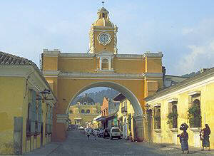
Famed for its colonial architecture and Easter
processions, Antigua Guatemala is a quiet beautiful town nestled in a lush valley
surrounded by three imposing volcanoes. Two of the volcanoes, Agua and Acatenango
are dormant while Fuego remains active to this day.
The climate of Antigua is spring like all year round making it a wonderful year round destination. Antigua has been named a World Cultural Patrimony center by UNESCO and is one of the country's most popular tourist destinations, offering a truly outstanding variety of elegant restaurants, hotels and specialty shops. Many people come to study in Antigua's many exceptional Spanish language schools, which have become world renown for the quality of their instruction.
 Founded
in 1543, Antigua was originally known as the Very Noble and Loyal City of Saint
James of the Knights of Guatemala and was the third capital founded by the unlucky
Spaniards in Guatemala. The first, a temporary headquarters near the Maya city
of Iximche, was abandoned after the city's Kaqchiquel inhabitants rebelled at
exorbitant demands for gold. The second, today called Ciudad Vieja (found
a short distance from Antigua), was washed away in a flood. The third city, now
known as Antigua Guatemala, served as the capital of all Central America for
230 years, and was home to a number of religious orders that built elaborate
monasteries and convents. Founded
in 1543, Antigua was originally known as the Very Noble and Loyal City of Saint
James of the Knights of Guatemala and was the third capital founded by the unlucky
Spaniards in Guatemala. The first, a temporary headquarters near the Maya city
of Iximche, was abandoned after the city's Kaqchiquel inhabitants rebelled at
exorbitant demands for gold. The second, today called Ciudad Vieja (found
a short distance from Antigua), was washed away in a flood. The third city, now
known as Antigua Guatemala, served as the capital of all Central America for
230 years, and was home to a number of religious orders that built elaborate
monasteries and convents.
The disaster-prone city was rebuilt after each of a dozen earthquakes and much of what can be seen today was built following the earthquake of 1717. Finally, after a devastating quake in 1773, Guatemala's governor ordered the city abandoned and a new capital built where present-day Guatemala City now stands. The ruined houses and structures lay, virtually forgotten, until the latter half of the 19th-century, when coffee was planted in Antigua's fertile valley and interest in the colonial city reawakened. Spectacularly beautiful, the city's quiet sun washed cobblestone streets today are often occupied by local artists with easels and paint boxes set up lovingly painting the scene of a volcano framed by a colonial arch, and jade nearby.
The contemporary Antigua is a cosmopolitan center of learning, with a fine library and research institute for visiting archaeologists, a cultural center that hosts films and plays, dozens of language schools and a biennial arts festival featuring performances of ballet, opera and classical music. It is also the site of annual processions during Easter week, the most beautiful religious celebration in the Americas.
Ruins of convents and monasteries, which have been
partially destroyed by earthquakes over the years, can be found throughout the
city. The most popular of these ruins include La Merced, Las Capuchinas, the
Cathedral, and the Franciscan monastery. The baroque facade of La Merced and
its lovely fountain are some of the city's most photographed architectural details.
In Las Capuchinas, visitors can see how architects tried to deal with the problem
of earthquakes using short thick pillars to sustain arches.
Return to top
|